

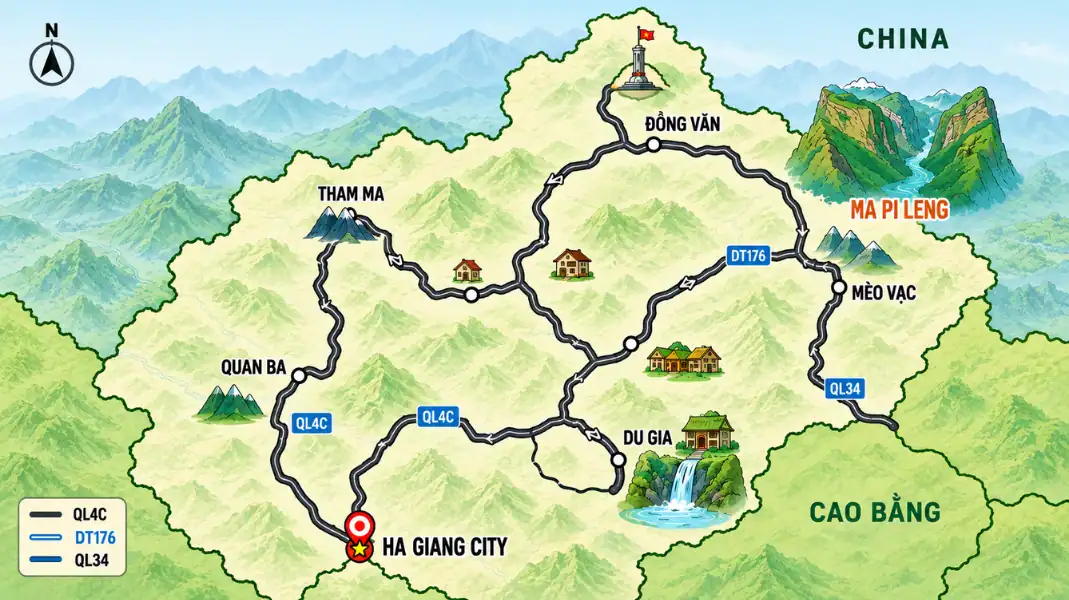
Finding your way around the Ha Giang Loop is easier than it looks, as long as you prepare before you leave the city. This guide is about navigation: which maps to download, which places to save, where to find fuel and money, and what to check before each day. For the route itself, stage by stage, see our Ha Giang Loop overview and our Ha Giang Loop map guide. Ha Giang has been part of Tuyen Quang province since July 2025.
Which direction to ride
The Loop can be ridden either way. Most trips go north from Ha Giang city through Quan Ba and Yen Minh to Dong Van, cross the Ma Pi Leng Pass to Meo Vac, then come back south through Du Gia. Each direction simply changes when the big views come.
Total distance: most Loops cover about 350 to 400 km. Our 4-day route is about 375 km.
The main roads:
- National Highway 4C: the main road north from Ha Giang city through Quan Ba, Yen Minh and Dong Van to Meo Vac.
- The road south from Meo Vac to Du Gia: quieter, narrower and rougher, with broken patches after rain.
- From Du Gia back to Ha Giang city: through valleys and forest to the city.
The 4-day route at a glance
| Day | Stage | Distance | Highlights |
|---|---|---|---|
| 1 | Ha Giang city to Yen Minh | About 96 km | Bac Sum Pass, Quan Ba Heaven Gate, Twin Mountains |
| 2 | Yen Minh to Dong Van via Lung Cu | About 115 km | Tham Ma Pass, Hmong King’s Palace, Lung Cu Flag Tower |
| 3 | Dong Van to Meo Vac and Du Gia | About 90 km | Ma Pi Leng Pass, Nho Que River and Tu San Canyon |
| 4 | Du Gia to Ha Giang city | About 74 km | Du Gia waterfall, valleys and forest |
Mountain roads are slow. Plan on short distances each day, with time for viewpoints, villages and bad weather.
Places worth saving before you go
Save these places in your offline map before you leave Ha Giang city. Search them by name rather than relying on coordinates copied from the internet, which are often wrong. There are gaps in the mobile signal in the mountains, so do not count on loading maps on the road.
| Place | Why save it |
|---|---|
| Ha Giang city | Start and end of the Loop; buses, fuel, ATMs |
| Quan Ba Heaven Gate | First big viewpoint, above the Twin Mountains |
| Tham Ma Pass | Famous switchbacks between Yen Minh and Dong Van |
| Lung Cu Flag Tower | Detour to the far north |
| Dong Van old quarter | Overnight stop on most Loops |
| Ma Pi Leng Pass viewpoint | Stop only at proper pull-offs |
| Nho Que River boat landing | Easy to miss; ask your guide for the turning |
| Du Gia | Village and waterfall in the south of the Loop |
Fuel and cash on the Loop
Petrol stations are found in the main towns. Between towns, some shops sell fuel in bottles, but do not rely on it.
- Ha Giang city: several petrol stations. Fill up before heading north.
- Quan Ba (Tam Son): fuel in town.
- Yen Minh: fuel in town. A good place to fill up before the plateau.
- Dong Van: fuel in town.
- Meo Vac: fuel in town. Fill up before the road south to Du Gia.
- Du Gia: limited. Ask your guide.
The longest stretch with few services is between Meo Vac and Du Gia. Fill up in Meo Vac. Bring cash too: ATMs are found in the main towns, but not in villages. On TVPalm tours, your easy rider takes care of the fuel.
Permits and documents
Parts of the Loop are border areas, and foreign visitors need a border area permit.
| Document | Details |
|---|---|
| Passport | Carry it at all times; police checks can happen on the Loop |
| Border area permit | 260,000 VND per person (about 10 USD); TVPalm arranges it on its tours |
| Travel insurance | Required on TVPalm tours; PVI Inbound 2 insurance is included |
The border area permit costs 260,000 VND per person (about 10 USD). On TVPalm tours, we arrange it for you before departure. Always carry your passport.
For tours with an easy rider or a private car, see our Ha Giang Loop tour overview.
Navigation apps
- Google Maps (offline): download the Ha Giang area before you leave Hanoi. It shows the main roads well and works without mobile data.
- Maps.me or Organic Maps: useful offline maps with good detail on small roads.
- A local SIM card: there is a signal in towns and on much of the main road, with gaps in the mountains.
- Your guide: on narrow mountain roads, local knowledge matters more than any app.
The Dong Van Karst Plateau Geopark covers about 2,356 km² and was recognised as a UNESCO Global Geopark in 2010. Its limestone mountains explain why the roads wind so much: they follow the cliffs rather than cutting through them.
Checklist before you leave
- Download the offline map for the whole Loop, from Ha Giang city to Meo Vac and Du Gia.
- Save your accommodation for each night offline.
- Save the main viewpoints and the Nho Que River boat landing by name.
- In the rainy season, plan to leave early, and ask about the road south from Meo Vac before you set off.
- Note the towns with fuel and ATMs: Ha Giang city, Quan Ba, Yen Minh, Dong Van and Meo Vac.
FAQ
Can I ride the Loop clockwise?
Yes. The Loop can be ridden in either direction. What matters more is riding slowly on the cliff roads, never stopping on a bend, and following local advice on the day about road works and weather.
How long does the Loop take?
We recommend 4 days, with about 74 to 115 km a day: Ha Giang city to Yen Minh (about 96 km), Yen Minh to Dong Van via Lung Cu (about 115 km), Dong Van to Meo Vac and Du Gia (about 90 km), and Du Gia back to Ha Giang city (about 74 km). With more time, the Loop can be extended to Cao Bang and Ba Be Lake.
Is Google Maps reliable on the Loop?
It shows the main roads well. Its main limit is the mobile signal, so download offline maps first. In the mountains it can sometimes suggest small farm tracks: stay on the main road, and when in doubt, ask your guide or local people.
Written by Nguyễn Văn Trung, Founder of TVPalm, a specialist in mountain road travel, trekking and ecolodge stays in Northeast Vietnam.


